
We make printed maps you’ll want to keep
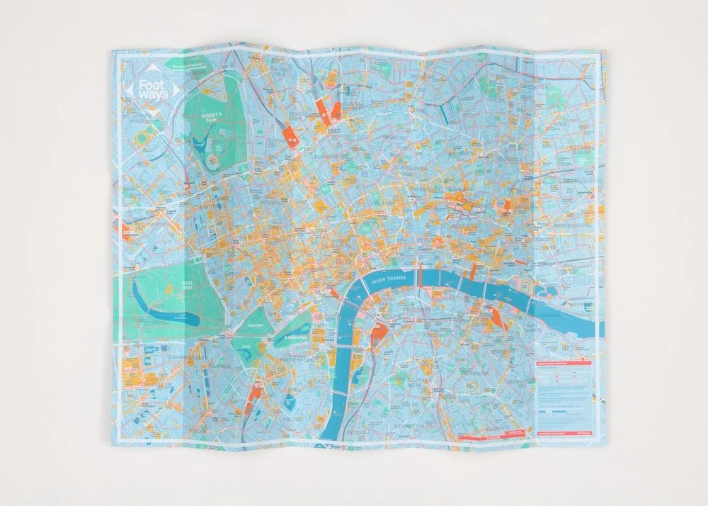
Central London Footways
Central London Footways reveals a network of quiet, enjoyable walking routes, with hundreds of features along the way. Many journeys that feel like a tube ride turn out to be a 15- or 20-minute walk.
First developed with Transport for London in 2020, the map has since been updated twice. The second edition was published in 2022, with sponsors Network Rail, LNER, the City of London Corporation, Central District Alliance, the Northbank BID and Urban Partners. The third edition was published in 2023 for the Coronation and distributed for free from Network Rail’s London stations.
The latest edition is designed by Applied Information, based on the first by Urban Good, with the reverse by Studio Bergini and illustrations by Charlotte Trounce.
The digital version has been viewed millions of times.
Buy a copy for £5 at Stanfords in Covent Garden or via our our shop.
Westminster Footways

Westminster Footways shows the whole borough from a pedestrian's perspective — a network of peaceful, attractive streets linking the bright lights of the West End and the nation's seats of power to quiet residential corners, green spaces and tranquil waterways.
The reverse highlights 30 favourite streets, from well-preserved Georgian terraces to bold modernist estates, alongside listed pubs and articles on Westminster's history and Soho's food culture.
Developed with Westminster City Council and launched in 2025, the map is part of the council's investment to make walking and wheeling safe, attractive and enjoyable. It was designed to get more people walking more and further, particularly residents of the borough's deprived wards and older people looking to stay active.
The map is designed by Applied Information, graphic design by Studio Bergini, with architectural illustrations by Paul Sammut.
Free copies are available from libraries and leisure centres across the City of Westminster, and a digital version is available here.
London Heritage Quarter

This pocket-sized map covers some of central London's most iconic ground — from Belgravia and Victoria through Parliament Square and Whitehall to the Strand and the Royal Courts of Justice.
It shows the Footways network of quiet, enjoyable streets, helping visitors navigate away from the main roads. The reverse is packed with insider tips, shortcuts, good-value places to eat and local history.
Footways developed the map for London Heritage Quarter, a partnership of four Business Improvement Districts: Victoria, Victoria Westminster, Whitehall and Northbank.
The first edition published in 2025 was an instant success and reprinted later that year. A third edition for 2026 shares details about the temporary closure of Charing Cross Station.
20,000 copies have been distributed at Victoria and Charing Cross stations and by LHQ Ambassadors, with a third print funded by Network Rail in 2026. A digital version, with around 80 points of interest and Footways photography, is also available on the LHQ website.

The Arc
This small illustrated map showcases a little known, quieter route linking Westminster Abbey, St James’s Park, Buckingham Palace and Victoria Station.
Produced by Footways, designed by Studio Bergini and illustrated by Charlotte Trounce, the distinctive map also reveals the area's rich history, hidden green spaces and places to eat and drink. The map is complemented by a series of lamp-column street banners, produced by Footways, which help people navigate the area and its destinations.
The map is published in print and digitally, with QR codes linking the banners to the digital route. As well as encouraging people to walk and explore, The Arc makes the case for future greening and public realm improvements along the route.
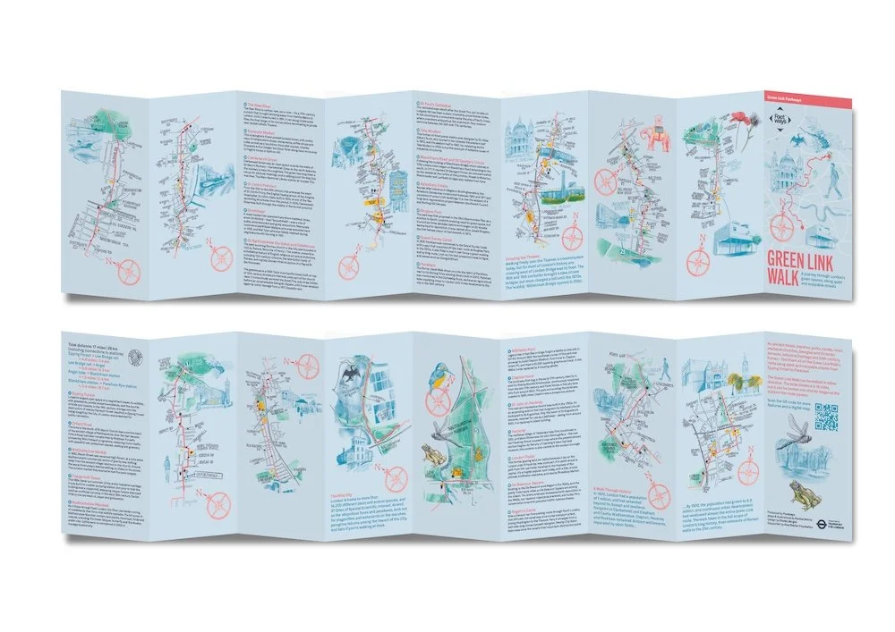
The Green Link
The Green Link is a 16-mile leisure walk crossing London from Epping Forest to Peckham, linking almost 40 green spaces and several waterways by mostly quiet streets. Footways' free illustrated map breaks the route into 12 stages, each richly illustrated by Rachel Morris and full of points of interest.
Inspired by the strip maps that guided travellers on England's roads in the 17th century, the map reveals London's green spaces and ancient streets that connect them, taking in everything from medieval churches to contemporary architecture.
The Green Link was conceived by Footways with the Ramblers, London Living Streets, Sustrans and CPRE London, and delivered by Transport for London. Free copies are available from libraries and destinations along the route, and a digital version can be viewed and downloaded at footways.london/the-green-link.
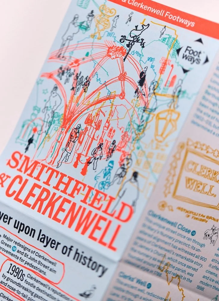

Smithfield & Clerkenwell
This pocket-sized map captures the character of one of London's most fascinating districts. Discover the area’s history of rebellion and innovation as you walk the peaceful streets of the Footways network. The map is packed with cultural institutions and places to eat and drink and it showcases a section of the Green Link Walk, London's newest long-distance route.
Footways developed the map with Islington Council, which has recently transformed Clerkenwell Green and St John Street into places for walking and living. First published as Clerkenwell Footways in 2024, it was reprinted in 2025 as Smithfield & Clerkenwell Footways for distribution at the Bartholomew Fayre.
The map features evocative line drawings by Laur Fitton and local knowledge from local historians and destinations. Free copies are available from destinations across the area, and a digital version is at footways.london/clerkenwell.
Camden Green Loop
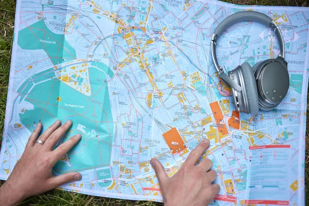
The Camden Green Loop map reveals the best of Camden Town, Euston and King's Cross — a walkable neighbourhood where green spaces, markets, cultural and industrial landmarks sit closer together than most realise.
The A2 folded map is full of well-loved spots like Camden Market and the Lock alongside details that are easily missed: the grooves worn by canal towropes, or the tomb in St Pancras Gardens that inspired the classic London phone box.
Footways developed the map with Camden Town Unlimited and Euston Town BIDs, through engagement sessions with local people and businesses.
The map also makes the case for change — showing where new crossings and small public spaces could better connect people and places.
10,000 free copies have been distributed through local organisations to residents and visitors, with a digital version available here.

Hackney Central Footways
Hackney Central Footways plots quiet, enjoyable walking routes to encourage people to walk to and around Hackney Central. It also celebrates the area's heritage, culture and businesses — from the medieval St Augustine's Tower to the ancient footway down the Narrow Way and through London Fields.
Footways developed the map with local walk guides, community groups, campaigners and historians, and it was funded by Hackney Council's Hackney Central Impact & Ideas Fund — a programme to strengthen the town centre's economy, character and community wellbeing after the pandemic. The printed map is designed by Applied Information and Studio Bergini, with illustrations by Jane Smith and printing by Calverts.
Launched in 2023, the map's free print run was quickly snapped up. A digital version is available at footways.london/hackney.
London Nature Trails
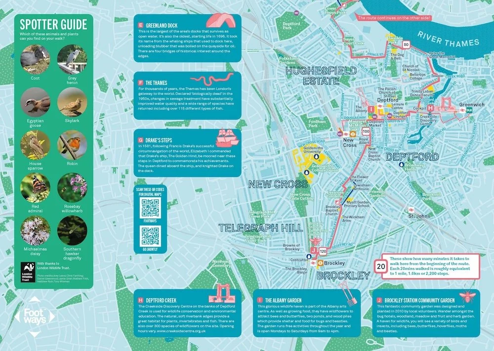
The London Nature Trails are four walking routes that connect Londoners to nature in the city's most built-up areas, following canals, rivers, parks, woodlands and nature reserves, with interesting cultural and historical features picked out along the way.
Each can be walked as a full day out or in shorter sections: Wanstead to Royal Docks in the east, Brockley to Bermondsey in the south, Swiss Cottage to King's Cross in the centre, and Wembley Stadium to Burnt Oak in the north.
Footways created the trails for the Greater London Authority, working with the London Wildlife Trust, the Ramblers, Go Jauntly and Transport for London. They were designed to help address the inequalities in access to green space across the city, and were promoted locally to reach communities who walk less often.
The trails were launched in 2022 as printed and digital maps. The printed maps are now out of stock, but you can follow the routes via the Footways website or the Go Jauntly app, with a London Wildlife Trust spotter guide to help you find animals and plants as you walk. footways.london/london-nature-trails.
Or follow our routes online
Don’t forget to enable your location to trace the routes from the street. The map has been designed with and supported by Mapbox.